HAZARDOUS WEATHER WARNING ISSUED BY NATIONAL WEATHER SERVICE
 Most of our viewers already know there is some frigid temps on the way the next couple of days. With potential for sub-zero temperatures, it is recommended to take certain precautions against the cold. If going outside, wear layers of clothing – not just one big coat. Make sure your vehicle has plenty of gas if traveling. If using room heaters, keep an eye on them and don’t let them have anything near-by that would catch on fire. Stay in touch with family and friends to insure they’re keeping warm. Make sure your water pipes are insulated and possibly leave a pencil lead size stream running to help prevent freezing. Make sure pets are inside or provisions are made for outside stays that will keep them warm (warm garage etc) . If possible, have a safe alternative heating source for your home in case of power outages which means if using a fuel heater, it should be well ventilated to the outside.
THIS HAZARDOUS WEATHER OUTLOOK IS FOR MIDDLE TENNESSEE.
.DAY ONE…TODAY AND TONIGHT.
AN ARCTIC COLD FRONT WILL MOVE THROUGH MIDDLE TENNESSEE LATE
TONIGHT INTO WEDNESDAY…WITH POTENTIAL FOR SOME LIGHT SNOW ALONG
THE FRONT. A DUSTING OF SNOW IS POSSIBLE.
.DAYS TWO THROUGH SEVEN…WEDNESDAY THROUGH MONDAY.
AN ARCTIC COLD FRONT WILL MOVE THROUGH MIDDLE TENNESSEE EARLY
WEDNESDAY…WITH POTENTIAL FOR SOME LIGHT SNOW ALONG THE
FRONT. A DUSTING OF SNOW IS POSSIBLE.
GUSTY NORTH WINDS OF 15 TO 25 MPH WITH GUSTS UP TO 35 MPH ARE
EXPECTED ON WEDNESDAY BEHIND THE FRONT…AND A WIND ADVISORY MAY
BE NECESSARY.
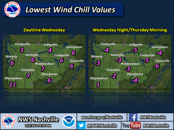
THE GUSTY NORTH WINDS COMBINED WITH THE BITTERLY COLD TEMPERATURES
IN TEENS AND SINGLE DIGITS WEDNESDAY INTO WEDNESDAY NIGHT WILL
CREATE WIND CHILLS BELOW ZERO AT TIMES…AND A WIND CHILL ADVISORY
MAY BE REQUIRED.
")