NWS: SNOW ACCUMULATION RAISED FOR CUMBERLAND COUNTY…FOR NOW
We are still under a Winter Storm Warning in effect from 9 pm this (Sunday) evening until 6 pm CST Monday. The predictions of snowfall amounts vary with almost every weather statement from area meteorologist’s -ranging from us getting lots of snow to some snow to ‘ice pellets’. One thing seem certain though, we’re going to get some form of frozen precipitation and it ‘might’ be a lot of it. No one seems totally confident we’ll get 4 inches or 10 inches but whatever it brings traveling is going to be very dangerous and it is going to be very cold keeping the snow/sleet/pellets around for awhile.
The following is the latest statement from the National Weather Service regarding snowfall amounts in Middle Tennessee showing the potential for up to 10 inches for the Cumberland Plateau as long as the weather system doesn’t move farther north:
Here is our latest thinking on snowfall amounts, but please know that we have a tremendous amount of uncertainty regarding these amounts!!! The reason for the uncertainty is that overnight computer model data shifted the track of the storm system farther north, which means we could be looking at a combination of snow, sleet, freezing rain, and even rain. If some of our reliable computer models continue to stick with this trend later this morning, we’re going to have to start lowering these amounts a lot. 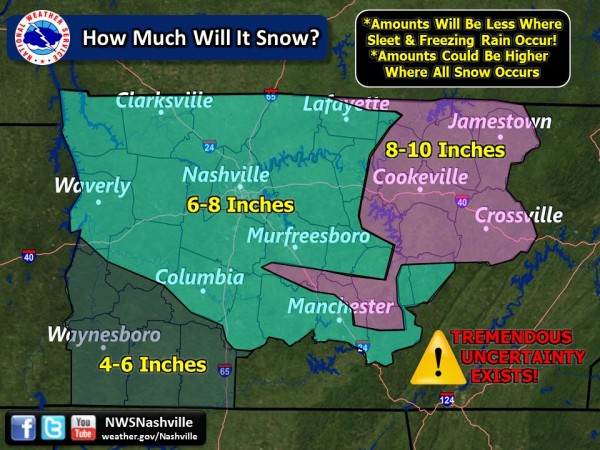
")