POSSIBLE SNOW IN THE FORECAST FOR EAST TN BRINGING IN THE OFFICIAL START OF WINTER ON THURSDAY
Blustery cold temperatures will be possible Monday and Tuesday in East Tennessee.
KNOXVILLE, Tenn. — A cold front is forecast to move into the area Monday that will bring in much colder air and blustery conditions.
Highs on Monday will be in the 40s with wind chill factors in the 30s. Winds will be breezy out of the northwest with gusts up to 25 mph.
Some areas could see the chance for a wintry mix depending on the timing of the cold air and how much moisture is in place. Models are showing a shallow layer of moist air that could mean a wintry mix for some and snow for others.

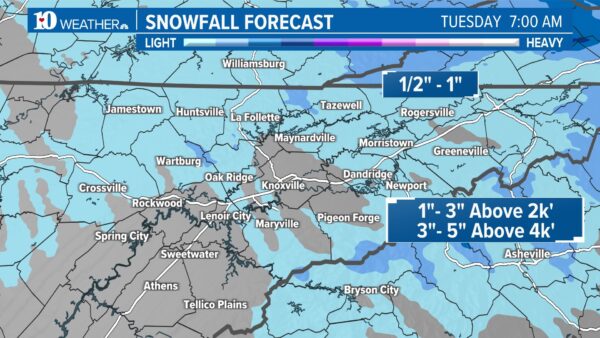
1″-3″ of snow will be possible for areas above 1,500 feet. 3″-5″ of snow will be possible for areas above 3,000 feet. Keep in mind, all the ingredients need to come together for snow to happen. It does look like the higher elevations will have the best chance for accumulation.
Map credit Channel 10 News CLICK HERE FOR MORE MAPS
Sunshine will return Tuesday although highs will be almost 15 degrees below average in spots. A slow warming trend will return by the end of the week.


Winter starts on Thursday at 10:27 p.m.
")