

ENJOY THE WARMTH BUT GET READY FOR THE PRICE, SEVERE WEATHER COMING
THE WEATHER CHANNEL
First up, record warmth for this time of year will be in place over much of the South this week. An energetic U-shaped jet stream trough will swing over that warm, humid air, providing the wind shear and instability needed for severe thunderstorms. It could start as early as Wednesday with the front pushing through our area.
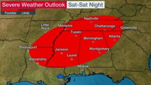
By Saturday (New Year’s Day), a more substantial severe weather threat might develop from the lower Mississippi and Tennessee valleys to the southern Appalachians. This threat may last into Saturday night in some of these areas.
There is the possibility that severe thunderstorms could initially fire up late Friday night into the early morning hours of Saturday from the ArkLaTex region into much of Arkansas, far western Tennessee and northwest Mississippi. Those storms could produce damaging winds, large hail and a few tornadoes.
For now, NOAA’s Storm Prediction Center has highlighted the locations below from northern Louisiana and southern and eastern Arkansas to Tennessee, Mississippi, southern Kentucky, northern and central Alabama and north Georgia as the area with the highest chance of at least some severe thunderstorms Saturday and Saturday night.
Damaging thunderstorm winds, hail and tornadoes are possible in these areas.